Kabul
| Kabul کابل |
|
|---|---|
| — City — | |
 |
|
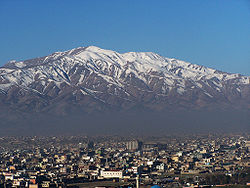
 Kabul
|
|
| Coordinates: | |
| Country | |
| Province | Kabul Province |
| No. of sectors | 18 |
| Government | |
| - Mayor | Mohammad Yunus Noandesh |
| Area | |
| - City | 275 km2 (106.2 sq mi) |
| - Metro | 425 km2 (164.1 sq mi) |
| Elevation | 1,790 m (5,873 ft) |
| Population (2008) | |
| - Metro | 2,850,000 |
| [1] | |
| Time zone | Afghanistan Standard Time (UTC+4:30) |
Kabul (Persian: کابل Kābol IPA: [kɒːˈbol]; Pashto: کابل Kābul IPA: [kɑˈbul];[2] archaic Caubul), is the capital and largest city of Afghanistan, located in the Kabul Province. According to the 2008 official estimates, the population of Kabul metropolitan area is 2.8 million people.[1]
It is an economic and cultural centre, situated 5,900 ft (1,800 m) above sea level in a narrow valley, wedged between the Hindu Kush mountains along the Kabul River. The city is linked with Kandahar, Herat and Mazar-e Sharif via a circular highway that stretches across the country. It is also the start of the main road to Jalalabad and further to Peshawar, Pakistan.
Kabul's main products include munitions, cloth, furniture and beet sugar, but since 1978, a state of nearly continuous war has limited the economic productivity of the city. Economic productivity has improved since the establishment of the Islamic Republic of Afghanistan in late 2001.[3]
Kabul is about 3,500 years old, many empires have long fought over the city for its strategic location along the trade routes of South and Central Asia. From 1504 to 1526, Kabul was the first and original capital of the Mughal dynasty under Babur. It remained under Mughal rule until 1738, when Nader Shah Afsharid and his forces confiscated it.[4] After the death of Nader Shah in 1747, the city fell to Ahmad Shah Durrani who quickly added it to his new Afghan Empire. In 1776, Timur Shah Durrani made it the capital of modern Afghanistan.[5] Since the Soviet war in Afghanistan in the 1980s, the city has been a target of militia or rebel groups. It is currently being re-developed[6] but bomb attacks by Taliban militants are slowing down the reconstruction process.
Contents |
History
| History of Afghanistan | |||||||||||||||||
|---|---|---|---|---|---|---|---|---|---|---|---|---|---|---|---|---|---|
 |
|||||||||||||||||
| See also | |||||||||||||||||
| Ariana · Khorasan | |||||||||||||||||
| Timeline | |||||||||||||||||
|
Pre-Islamic period
|
|||||||||||||||||
|
Islamic conquest
|
|||||||||||||||||
|
Modern history
|
|||||||||||||||||
|
|
Antiquity
The city of Kabul is thought to have been established between 2000 BC and 1500 BC.[7] It was once a centre of Zoroastrianism, then later of Buddhism. The word "Kubhā" is mentioned in Rigveda (composed between 1700–1100 BC), which appears to refer to the Kabul River. The Rigveda praises it as an ideal city, a vision of paradise set in the mountains.[8] During this period the Kabul area was part of Ariana and ruled by ancient Persian emperors. There is a reference to a settlement called Kabura by the rulers of the Achaemenid Empire around 400 BC, which may be the basis for the use of the name Kabura (Κάβουρα) by Ptolemy.[9] Alexander the Great explored the area after his conquest of the Achaemenid Empire in 330 BC but not mention was made of Kabul.[10] The city became part of the Seleucid Empire before becoming part of the Maurya Empire. The Bactrians founded the town of Paropamisadae near Kabul, but it was later ceded to the Mauryans in the 1st century BC.

According to many noted scholars, the Sanskrit name of Kabul is Kamboj.[11][12][13][14][15] It is mentioned as Kophes or Kophene in the classical writings. Gazetteer of Bombay Presidency 1904 maintains that the ancient name of Kabul was Kambojapura, which Ptolemy mentions as Kaboura (from Ka(m)bo(j)pura?) in 160 AD. Hsuan Tsang refers to the name as Kaofu (高附), which according to J.W. McCrindle,[16] Sylvain Lévi,[17] B.C. Law,[18] R.K. Mukkerji,[19] N.L. Dey[20] and many other scholars,[21] is equivalent to Sanskrit Kamboja (Kamboj/Kambuj). Kaofu was also the appellation of one of the five tribes of the Yuechi who had migrated from across the Hindukush into the Kabul valley around the beginning of the Christian era.[22] According to some scholars, the fifth clan mentioned among the Tochari/Yuechi may have been a clan of the Kambojas[23]
The Greco-Bactrian Kingdom captured Kabul from the Mauryans in the early 2nd century BC, then lost the city to their subordinates in the Indo-Greek Kingdom around the mid 2nd century BC. Indo-Scythians expelled the Indo-Greeks by the mid 1st century BC, but lost the city to the Kushan Empire nearly 100 years later. It was conquered by Kushan Emperor Kujula Kadphises in the early 1st century AD and remained Kushan territory until at least the 3rd century AD.[24][25]
Around 230 AD, the Kushans were defeated by the Sassanid Empire and replaced by Sassanid vassals known as the Kushanshas or Indo-Sassanids. In 420 AD the Kushanshahs (Kushan kings) were driven out of Afghanistan by the Xionites tribe known as the Kidarites, who were then replaced in the 460s by the Hephthalites. It became part of the surviving Turk Shahi Kingdom of Kapisa, also known as Kabul-Shahan. Barhatkin was the first Shahi king [26] followed by King Khingala [27] about 5th Century.
The Kabul rulers are probably identical with the so called Turk Shahi kings who are known from other sources, as for instance from the work of the earlier Islamic geographer, Abu Rahyan al-Biruni. This famous encyclopedic from Choresmia lived from AD 973 to about AD 1050 and worked at the court of the later Islamic ruler of East Afghanistan, Mahmud of Ghazni. In his large work on India (Tarikh al hind), al Biruni tells that the Turkic kings of Kabul and Gandhara claimed descent from King Kanishk, while at the same time they boasted of their Tibetan origins. They reigned according to al Biruni for 60 generations.[28]—Willem Vogelsang, 2002
The Kabul rulers built a huge defensive wall around the city to protect it from future invaders. This wall has survived until today and is also considered a historical site.
Islamic conquest to the Mongol invasion
In 674, the Islamic conquest reached modern-day Afghanistan. Kabul to the east fell in 879 despite the resistance of the Kabul Shahi.[29][30] In the 9th century Ya'qub bin Laith as-Saffar, a coppersmith turned ruler from Zaranj, further established Islam in Kabulistan. Over the centuries to come, the city was successively controlled by the Samanids, Ghaznavids, Ghurids, and Kartids.
Ibn Hawqal who is supposed to have written in the middle of the 10th century, observes that at Kabul, although the castle was occupied by Mohammadans, the town was still possessed by idolators, that is, by Hindus.[31]—H. Wilson and C. Masson
In the 13th century the Mongol horde passed through and fought with the local Turkic tribes in the area. Reports of a massacres in the close by Bamiyan is recorded around this period, where the entire population of the valley was annihilated by the Mongol troops. One of Genghis Khan's grandson is thought to be named "Kabul", which is believed to be the first documented mention of this name.[32] The name is again mentioned following the era of the Khilji dynasty when a Moroccan traveller, Ibn Battuta, visiting Kabul in 1333 writes:[33]
We travelled on to Kabul, formerly a vast town, the site of which is now occupied by a village inhabited by a tribe of Persians called Afghans.—Ibn Battuta, 1304-1369
Timurid and Mughal era

In the 14th century, Kabul rose again as a trading centre under the kingdom of Timur (Tamerlane). By 1504, the city was revitalized by Babur and made into his headquarters, which remained one of the principle cities of the Mughal Empire for over 200 years. Mirza Muhammad Haidar Dughlat, an Indian poet who visited at the time wrote:
Dine and drink in Kabul: it is mountain, desert, city, river and all else.—Haidar, 1499-1551
It was from here that Babur began his conquest of India in 1526. Babur wished to be buried in Kabul, a city he had always loved, but at first he was buried in Agra, India. Roughly nine years later his remains were dug back up and re-buried at Bagh-e Babur (Gardens of Babur) in Kabul by Sher Shah Suri on orders by Babur's wife. The inscription on his tomb contains Persian words penned by Babur:
.اگر پردیس روی زمین است همین است و همین است و همین است
(If there is a paradise on earth, it is this, it is this, it is this!)
—Babur (1483-1531) [34]
The city was often contested by Babur's sons, especially Kamran Mirza and Humayun. Humayun was chased away from Hindustan by Sher Shah Suri but was able to return in November 1545 with Persian aid, where he is believed to have taken Kabul without any blood-spills. Kamran managed to retake Kabul twice but he remained a hated figure to the residents of the city, as his periods of rule involved atrocities against large numbers of them. Following his third and final ejection from Kabul in 1552, Kamran fled and was captured in Punjab, by Hindu General 'Hemu' of Islam Shah, who was ruling North India. Kamran was handed over to Humanyun in Kabul, who made him blind.
Durrani Empire and the Afghan nation-state
Nader Shah Afshar invaded and occupied the city briefly in 1738 but was assassinated nine years later. Ahmad Shah Durrani, who commanded 4,000 Abdali Afghans under Nader Shah, asserted Pashtun rule in 1747 and further expanded his new Afghan Empire. His ascension to power marked the beginning of Afghanistan. His son Timur Shah Durrani, after inheriting power, transferred the capital of Afghanistan from Kandahar to Kabul in 1776.[35] Timur Shah died in 1793 and was succeeded by his son Zaman Shah Durrani. The first European to visit Kabul was the 18th century English traveller George Foster, who described it as "the best and cleanest city in Asia".[8]
In 1826, the kingdom was claimed by Dost Mohammad Khan and taken from him by the British Indian Army in 1839, who installed the unpopular Shah Shuja. An 1841 local uprising resulted in the loss of the British mission and the subsequent Massacre of Elphinstone's Army of approximately 16,000 foreign forces, which included civilians and camp followers on their retreat from Kabul to Jalalabad. In 1842 the British returned, plundering Bala Hissar in revenge before fleeing back to British India (now Pakistan). Dost Mohammed returned to the throne.
The British and Indian forces invaded in 1878 as Kabul was under Sher Ali Khan's rule, but the British residents were again massacred. The invaders again came in 1879 under General Roberts, partially destroying Bala Hissar before retreating to British India (Pakistan). Amir Abdur Rahman Khan was left in control of the country.
In the early 20th century King Amanullah Khan rose to power. His reforms included electricity for the city and schooling for girls. He drove a Rolls-Royce, and lived in the famous Darul Aman Palace. In 1919, after the Third Anglo-Afghan War, Amanullah announced Afghanistan's independence from foreign affairs at Eidgah Mosque. In 1929 Ammanullah Khan left Kabul due to a local uprising orchestrated by Habibullah Kalakani and Ammanullah's brother, Nader Khan, took control over the nation. King Nader Khan was assassinated in 1933 and the throne was left to his 19-year-old son, Zahir Shah, who became the long lasting King of Afghanistan.
During this period between the two World Wars France and Germany worked to help develop the country in both the technical and educational spheres. Both countries maintained high schools and lycees in the capital and provided an education for the children of elite families.[36] Kabul University opened in 1932 and soon was linked to both European and American universities, as well as universities in other Muslim countries in the field of Islamic studies.[37] By the 1960s the majority of instructors at the university had degrees from Western universities.[37]

When Zahir Shah took power in 1933 Kabul had the only 6 miles of rail in the country, few internal telegraph or phone lines and few roads. He turned to the Japanese, Germans and Italians for help developing a modern network of communications and roads.[38] A radio tower built by the Germans in 1937 in Kabul allowed instant communication with outlying villages.[39] A national bank and state cartels were organized to allow for economic modernization.[40] Textile mills, power plants and carpet and furniture factories were also built in Kabul, providing much needed manufacturing and infrastructure.[40]
In 1955 the Soviet Union forwarded $100 million in credit to Afghanistan, which financed public transportation, airports, a cement factory, mechanized bakery, a five-lane highway from Kabul to the Soviet border and dams.[41]
In the 1960s, Kabul developed a cosmopolitan mood. The first Marks & Spencer store in Central Asia was built there. Kabul Zoo was inaugurated in 1967, which was maintained with the help of visiting German zoologists. Many foreigners began flocking to Kabul with the increase in global air travels around that time. The nation's tourism industry was starting to pick up rapidly for the first time. Kabul experimented with liberalization, dropping laws requiring women to wear the burka, restrictions on speech and assembly loosened which led to student politics in the capital.[42] Socialist, Maoist and liberal factions demonstrated daily in Kabul while more traditional Islamic leaders spoke out against the failure to aid the Afghan countryside.[42] A 1969 a religious uprising at the Pul-e Khishti Mosque protested the Soviet Union's increasing influence over Afghan politics and religion. This protest ended in the arrest of many of its organizers, including Mawlana Faizani, a popular Islamic scholar.In the early 1970s Radio Kabul began to broadcast in other languages besides Pashtun which helped to unify those minorities that often felt marginalized, however this was put to a stop with Daoud's revolution in 1973.[43]
.jpg)
In July 1973, Zahir Shah was ousted in a nonviolent coup and Kabul became the capital of a republic under Mohammed Daoud Khan, the new President. Daoud's revolution was actually supported by the communist party in the city, the PDP. The support of the PDP helped to prevent a violent clash in his coup in 1973. He named himself President of this new democracy and planned to institute reforms. Daoud was the long standing prime minister, and while he instituted a republic he had Soviet leanings in terms of political allies.[44] He had welcomed Soviet military aid and advisors in 1956 and the nation slowly took on the appearance of what one US diplomat called a "Soviet-style police state, where there is no free press, no political parties, and where the ruthless suppression of minorities is the established pattern."[45] Conversely, some of the people of Kabul who lived under King Zahir Shah describe the period before the April 1978 Saur Revolution as a sort of golden age. All the different ethnic groups or tribes of Afghanistan lived together harmoniously and thought of themselves first and foremost as Afghans. They intermarried and mixed socially.[8]
In the later years of his leadership, Daoud began to shift favour from the Soviet Union to Islamic nations, expressing admiration for their wealth from oil and expecting economic aid from them to quickly surpass that of the Soviet Union.[46] The slow speed of reforms however frustrated both the Western educated elite and the Russian trained army officers.[47] Daoud forced many communists out of his government, which unified the various communist factions within the city.[47]
This would ultimately lead to the Saur Revolution which occurred on April 27, 1978. The PDPA, the People's Democratic Party Army, seized the palace and killed Daoud and his family along with many of his supporters.[47] The new communist regime moved quickly to institute reforms. Private businesses were nationalized in the Soviet manner.[48] Education was modified into the Soviet model, with lessons focusing on teaching Russian, Leninism-Marxism and learning of other countries belonging to the Soviet bloc.[48] Rural guerrillas and disaffected army deserters took up arms in the name of Islam, due to the communist regime's increasing rejection of it.[48] This rebellion would eventually lead to the invasion of Afghanistan by Russian forces.[49]
Soviet invasion and civil war

After the Soviet invasion of Afghanistan, on December 24, 1979, the Red Army occupied the capital. They turned the city into their command centre during the 10-year conflict between the Soviet-allied government and the Mujahideen rebels. The American Embassy in Kabul closed on January 30, 1989. The city fell into the hands of local militias and warlords after the 1992 collapse of Mohammad Najibullah's pro-communist government.[50] As these forces between Tajiks, Uzbeks, Hazaras, and Pashtuns divided into warring factions, the city increasingly suffered. In December, the last of the 86 city trolley buses came to a halt because of the conflict. A system of 800 public buses continued to provide transportation services to the city. By 1993 electricity and water in the city was completely out. At this time, Burhannudin Rabbani's Tajik fighters (Jamiat-e Islami) held power but the nominal Gulbuddin Hekmatyar's Hezb-e Islami, Dostum's Junbish and Abdul Ali Mazari's Hezbe Wahdat began shelling the city, which lasted until 1996. Initially the factions in the city aligned to fight off Hekmatyar but diplomacy between the groups quickly broke down.[51] Due to the groups being mainly divided by ethnic origins the fighting quickly took on a genocidal aspect. The goal was to "purposefully eliminate people of a different identity ... by means of large-scale slaughter, coercive relocation, extortion and other modes of intimidation, such as rape and torture."[52] Political control became almost feudal in manner, with a warlord controlling whatever area he and his followers could manage to militarily conquer. Tens of thousand of Kabul citizens were killed and many more fled as refugees. The United Nations estimated that 90% of the buildings in Kabul were destroyed during these years.
Kabul was captured by the Taliban on September 26, 1996,[53] publicly lynching ex-President Najibullah and his brother. During this time, all the fighting between the rival groups came to a sudden end. Burhannudin Rabbani, Gulbuddin Heckmatyar, Abdul Rashid Dostum, Ahmad Shah Massoud, and the rest of the warlords all fled the city. The Taliban rule also did not last long, which made Afghanistan come to the brink of starvation.
US-British invasion

Approximately five years later, in October 2001, the United States armed forces assisted by British Armed Forces invaded the country during Operation Enduring Freedom. The Taliban abandoned Kabul in the following months due to extensive American and British bombing, while the Afghan Northern Alliance (former mujahideen and warlords) came to retake control of the city. In late December 2001 Kabul became the capital of the Afghan Transitional Administration, which transformed to the present Government of Afghanistan that is led by President Hamid Karzai.
Since the beginning of 2003, the city of Kabul has been slowly developing with the help of foreign investment. It is also the scene of many suicide bombings and powerful explosions where many people become casualties. Most attacks are carried out against government and military installations but the majority of the victims are civilians. From early 2002 to 2008, security was provided by NATO's International Security Assistance Force (ISAF), but now the newly trained Afghan National Police (ANP) and the Afghan National Army (ANA) are in charge of the area.
Climate
Kabul has a semi-arid, continental climate (Köppen climate classification BSk) with precipitation concentrated in the winter (sometimes falling as snow) and spring months. Summers are long and hot, but have very low humidity. Autumn, in October and November, is warm and dry. Winters are cold but short, lasting from December to March. Spring in Kabul starts in late March and is the wettest time of the year.
| Climate data for Kabul | |||||||||||||
|---|---|---|---|---|---|---|---|---|---|---|---|---|---|
| Month | Jan | Feb | Mar | Apr | May | Jun | Jul | Aug | Sep | Oct | Nov | Dec | Year |
| Average high °C (°F) | 4.5 (40.1) |
5.5 (41.9) |
12.5 (54.5) |
19.2 (66.6) |
24.4 (75.9) |
30.2 (86.4) |
32.1 (89.8) |
32.0 (89.6) |
28.5 (83.3) |
22.4 (72.3) |
15.0 (59) |
8.3 (46.9) |
19.6 (67.3) |
| Average low °C (°F) | -7.1 (19.2) |
-5.7 (21.7) |
0.7 (33.3) |
6.0 (42.8) |
8.8 (47.8) |
12.4 (54.3) |
15.3 (59.5) |
14.3 (57.7) |
9.4 (48.9) |
3.9 (39) |
-1.2 (29.8) |
-4.7 (23.5) |
4.3 (39.7) |
| Precipitation mm (inches) | 34.3 (1.35) |
60.1 (2.366) |
67.9 (2.673) |
71.9 (2.831) |
23.4 (0.921) |
1.0 (0.039) |
6.2 (0.244) |
1.6 (0.063) |
1.7 (0.067) |
3.7 (0.146) |
18.6 (0.732) |
21.6 (0.85) |
312.0 (12.283) |
| Source: World Meteorological Organisation (UN) [54] | |||||||||||||
| Kabul [54] | ||||||||||||||||||||||||||||||||||||||||||||||||||||||||||||
|---|---|---|---|---|---|---|---|---|---|---|---|---|---|---|---|---|---|---|---|---|---|---|---|---|---|---|---|---|---|---|---|---|---|---|---|---|---|---|---|---|---|---|---|---|---|---|---|---|---|---|---|---|---|---|---|---|---|---|---|---|
| Climate chart () | ||||||||||||||||||||||||||||||||||||||||||||||||||||||||||||
|
||||||||||||||||||||||||||||||||||||||||||||||||||||||||||||
|
||||||||||||||||||||||||||||||||||||||||||||||||||||||||||||
Administration
Kabul City is one of the 15 districts of Greater Kabul (the province), and is divided into 18 sectors. Each sector covers several neighborhoods of the city. The number of sectors in Kabul increased from 11 to 18 in 2005.
Unlike other cities of the world, Kabul City has two independent councils or administrations at once: Prefecture and Municipality. The Prefect, who is also the Governor of Kabul Province, is appointed by the Ministry of Interior, and is responsible for the administrative and formal issues of the entire province. The Mayor of Kabul City is selected by the President of Afghanistan, who engages in the city's planning and environmental work.
The police and security forces belong to the prefecture and Ministry of Interior. The Chief of Police is selected by the Minister of Interior and is responsible for law enforcement and security of the city.

Areas
Neighbourhoods in Kabul include:
- Shahr-e-Naw (New City)
- Wazir Akbar Khan
- Macrorayon (1, 2, 3 and 4)
- Khair Khana (1, 2 and 3)
- Murrad Khani
- Udkheyl
- Dashti Barchi
- Kartey Sakhi
- Qalai Wazir
- Khushhall Khan
- Afshar-e-Bala
- Microyan
- Kharabat
- Klola Pushta
- Taimany
- Dendana
- Shirpur
- Mahtab Qala
- Unci-Baghbanan
- Qalay-e-Chaman
- Kartey Parwan
- Kartey Naw (New Quarter)
- Kartey (3 & 4)
- Kartey-e-Vali
- Karte Seh
- Jangalak
- Darul-Aman
- Chahar Dehi
- Chehlstoon
- Chendawol
- Shahr-e-Kohna (Old City)
- Deh Buri
- Bibi Mahroo
- Char Qala
- Tania
Demographics

The Kabul metropolitan area has a population of 2.8 million inhabitants.[1] The wider Kabul province, which also includes rural areas, has a population of around 3.5 million people,[1] while the Kabul city's population makes almost 80 percent of the total provincial population.[55]
The population of the city reflects the general multi-ethnic, multi-cultural, and multi-confessional characteristics of Afghanistan. There is no official government report on the exact ethnic make-up of the city but according to a 2003 estimate by the National Geographic Society and a media report, Persian-speakers form the majority of the city's population, with Tajiks being the largest group[56] at approximately 45% followed by Hazaras at 25%. Pashtuns form another 25%.[57] The remaining 5% include Turkic-speaking Uzbek and Turkmen as well as Aimak, Baloch, Pashai and others. Regardless of their ethnic background, every resident of Kabul are referred to as Kabuli or Kabulai.
Nearly all the people of Kabul are Muslim, about 75% Sunnis and 25% Shias. Small number of Sikhs and Hindus are also found in the city. There is at least one Jew in Kabul, whose name is Zablon Simintov.
Transport

Kabul International Airport, located 25 kilometres (16 mi) from the centre of Kabul, is the country's main airport. It is a hub to Ariana Afghan Airlines, which is the national airlines carrier of Afghanistan. Kam Air, Pamir Airways, and Safi Airways also have their headquarters in Kabul. Airlines from nearby nations such as Pakistan, Iran, India, and several others also make stops at Kabul Airport. A new international terminal was built by the government of Japan and began operation in 2008. The new terminal is the first of three terminals to be opened so far. The other two will open once air traffic to the city increases. Passengers coming from most foreign nations use mostly Dubai for flights to Kabul. Kabul Airport also has a military air base which serves as the main airport for Afghan National Air Corps. NATO also uses the Kabul Airport, but most military traffic is based at Bagram Air Base, just north of Kabul. The Afghan National Army and Afghan National Police are in charge of the airport security. For the year of 2009, the militaries of Hungary and Poland were the operators of the entire airport, paying for the upkeep and protection of the facility, under command of NATO.
Bus service to most major cities of the country is available in Kabul although they are not as safe, especially for foreigners. The city's public buses (Milli Bus / "National Bus") take commuters on daily routes to many destinations. The service currently has approximately 800 buses but is gradually expanding and upgrading with more buses being added. The Kabul bus system has recently discovered a new source of revenue in whole-bus advertising from MTN similar to "bus wrap" advertising on public transit in more developed nations. There is also an express bus that runs from the city centre to Kabul International Airport for Safi Airways passengers. There are also yellow taxicabs just about anywe in and around the city.
Private vehicles are on the rise in Kabul, with Toyota, Nissan, and other dealerships in the city. People are buying new cars as the roads and highways are being improved. Most drivers in Kabul prefer owning a Toyota Corolla, one of Afghanistan's most popular car.[58] With the exception of motorcycles many vehicles in the city operate on LPG. Gas stations are mainly private-owned but the fuel comes from Iran. Bikes on the road are a common sight in the city.
Communications
GSM/GPRS mobile phone services in the city are provided by Afghan Wireless, Etisalat, Roshan and MTN. In November 2006, the Afghan Ministry of Communications signed a US 64.5 million dollar agreement with a company (ZTE Corporation) on the establishment of a countrywide fibre optical cable network. This will improve telephone, internet, television and radio broadcast services not just in Kabul but throughout the country.[59] Internet was introduced in the city in 2002 and has been expanding rapidly.
There are a number of post offices throughout the city. Package delivery services like FedEx, TNT N.V., and DHL are also available.
The city has many local-language radio stations, including Pashto and Dari, as well as some programs in the English language. The Afghan government has become increasingly intolerant of Indian channels and the un-Islamic culture they bring, and has threatened to ban them.
Education
Public and private schools in the city reopened since 2002 after they were shut down or destroyed from the fightings in the 1980s to the late 1990s. Boys and girls are strongly encouraged to attend schools under the Karzai administration but many more schools are needed not only in Kabul but throughout the country. The Afghan Ministry of Education has plans to build more schools in the coming years so that education is provided to all citizens of the country. The most well known high schools in Kabul include:
- Habibia High School, a British-Afghan school founded in 1903 by King Habibullah Khan.
- Lycée Esteqlal, a Franco-Afghan school founded in 1922.
- Amani High School, a German-Afghan school for boys founded in 1924.
- Aisha-i-Durani School, a German-Afghan school for girls.
The city's colleges and universities were renovated after 2002. Some of them have been developed recently, while others have existed since the early 1900s.

Universities in Kabul
- Kabul University
- Kabul Medical University
- Polytechnical University of Kabul (Kabul Polytechnic)
- American University of Afghanistan
- Higher Education Institute of Karwan
- Kateb Institute of Higher Education
- Rana Institute of Higher Education
- Bakhtar Institute of Higher Education
- Dawat University
- National Military Academy of Afghanistan
Places of interest

The old part of Kabul is filled with bazaars nestled along its narrow, crooked streets. Cultural sites include the Afghan National Museum, notably displaying an impressive statue of Surya excavated at Khair Khana, the ruined Darul Aman Palace, the Mausoleum of Emperor Babur and Chehlstoon Park, the Minar-i-Istiqlal (Column of Independence) built in 1919 after the Third Afghan War, the mausoleum of Timur Shah Durrani, and the imposing Id Gah Mosque (founded 1893). Bala Hissar is a fort destroyed by the British in 1879, in retaliation for the death of their envoy, now restored as a military college. The Minaret of Chakari, destroyed in 1998, had Buddhist swastika and both Mahayana and Theravada qualities.
Other places of interest include Kabul City Center, which is Kabul's first shopping mall, the shops around Flower Street and Chicken Street, Wazir Akbar Khan district, Babur Gardens, Kabul Golf Club, Kabul Zoo, Shah Do Shamshera and other famous Mosques, the Afghan National Gallery, Afghan National Archive, Afghan Royal Family Mausoleum, the OMAR Mine Museum, Bibi Mahroo Hill, Kabul Cemetery, and Paghman Gardens.
Tappe-i-Maranjan is a nearby hill where Buddhist statues and Graeco-Bactrian coins from the 2nd century BC have been found. Outside the city proper is a citadel and the royal palace. Paghman and Jalalabad are interesting valleys north and east of the city.


- Airports
- Kabul International Airport
- Parks
- Bāgh-e Bābur Park (Babur Gardens)
- Bāghi Bālā Park
- Lake Qargha Park
- Zarnegar Park
- Shar-e Naw Park
- Bagh-e Zanana
- Chaman-e-Hozori
- Bebi Mahroo Park
- Mosques
- Abdul Rahman Mosque
- Id Gah Mosque
- Pul-e Khishti Mosque
- Shah-e Do Shamshera Mosque
- Blue Mosque
- Mausoleums
- Mausoleum of Tamim Ansar
- Mausoleum of Timur Shah Durrani
- Mausoleum of Abdur Rahman Khan
- Mausoleum of Zahir Shah and Nadir Shah
- Museums
- Kabul Museum
- National Archives
- Negaristani Milli
- Hotels
Reconstruction and developments

As of October 2007, there are approximately 16 licensed banks in Kabul: including Da Afghanistan Bank, Afghanistan International Bank, Kabul Bank, Azizi Bank, Pashtany Bank, Afghan United Bank, Standard Chartered Bank, Punjab National Bank, Habib Bank and others. Western Union offices are also found in many locations throughout the city, which are mainly used by expatriate Afghans to transfer funds to their families at home.
A small sized indoor shopping mall (Kabul City Center) with a 4-star (Safi Landmark) hotel on the top six floors opened in 2005. A 5-star Serena Hotel also opened in 2005. Another 5-star Marriott Hotel is under construction. The landmark InterContinental Hotel has also been refurbished and is in operation. Modern apartment buildings are also being built across Kabul, as part of the attempt to modernize the city.
An initial concept design called the City of Light Development, envisioned by Dr. Hisham N. Ashkouri, Principal of ARCADD, Inc. for the development and the implementation of a privately based investment enterprise has been proposed for multi-function commercial, historic and cultural development within the limits of the Old City of Kabul along the Southern side of the Kabul River and along Jade Meywand Avenue,[63] revitalizing some of the most commercial and historic districts in the City of Kabul, which contains numerous historic mosques and shrines as well as viable commercial activities among war damaged buildings. Also incorporated in the design is a new complex for the Afghan National Museum. Dr. Ashkouri has signed a Memorandum of Understanding with His Excellency Ambassador Said Tayeb Jawad in Washington, D.C. to undertake this project and to develop it for actual implementation over the next 20 to 25 years. Dr. Ashkouri has presented the City of Light Plan to President Karzai and has received a letter of support from the President and the Minister of Urban Development in support of this project's development.

About 4 miles (6 km) from downtown Kabul, in Bagrami, a 22-acre (9 ha) wide industrial complex has completed with modern facilities, which will allow companies to operate businesses there. The park has professional management for the daily maintenance of public roads, internal streets, common areas, parking areas, 24 hours perimeter security, access control for vehicles and persons. Another phase with additional 27 acres (11 ha) of land will be added immediately proceeding the first phase.[64]
A $25 million Coca-Cola bottling plant was opened in 2006. Financing was provided by a Dubai-based Afghan family. President Hamid Karzai formally opened the facility in an attempt to attract more foreign investment in the city. In late 2007 the government announced that all the residential houses situated on mountains would be removed within a year so that trees and other plants can be grown on the hills. The plan is to try to make the city greener and provide residents with a more suitable place to live, on a flat surface. Once the plan is implemented it will provide water supply and electricity to each house. All the city roads will also be paved under the plan, which will solve transportation problems.[65]
NGOs
Numerous non-governmental organizations (NGOs), both national and international, are based in Kabul, conducting various activities to assist development in Afghanistan and provide humanitarian relief to the many victims which 30 years of war have produced.
The Aga Khan Development Network (AKDN) is the largest not-for-profit organization in Afghanistan. It has been involved in most major development projects, including the Serena Hotel, the first five-star hotel in Afghanistan, as well as the restoration of the Bagh-e Babur gardens. AKDN also launched the award-winning Roshan, Afghanistan's leading telecommunications provider. Over 93% of Roshan's staff comprises Afghan nationals, whose average age is 23; many employees only have a high school degree. Over 20% of Roshan's employees are women, and the company has shown that it is committed to promoting women in the workplace.
Afghanistan Information Management Services (AIMS) provides software development, capacity development, information management, and project management services to the Afghan Government and other NGOs, thereby supporting their on-the-ground activities.
The We Are the Future (WAF) Center is a child care centre whose aim is to give children a chance to live their childhoods and develop a sense of hope. The centre is managed under the direction of the mayor's office and the international NGO. Glocal Forum serves as the fundraiser, program planner and coordinator for the WAF centre. Launched in 2004, the program is the result of a strategic partnership between the Glocal Forum, the Quincy Jones Listen Up Foundation and Mr. Hani Masri, with the support of the World Bank, UN agencies and major companies.
Gallery
 InterContinental |
 Serena Hotel |
 Bagh-e Babur from a mountain top |
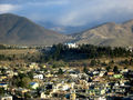
 Qargha lake, outside the city |
 Kabul City during the evening |
 Bagh-e Bala Park |
 Kabul Golf Park, outside the city |
 Darul Aman Palace |

See also
- 2002 Hindu Kush earthquakes
- City of Light Development
- Kabul Express
- Kabul Golf Club
- Kabulistan
- List of cities in Afghanistan
- Radio Kabul
Footnotes
- ↑ 1.0 1.1 1.2 1.3 "Afghanistan Statistical Yearbook 2008/09", Central Statistics Office
- ↑ Pronunciation in English varies, common are /ˈkɑːbəl/, /ˈkɑːbuːl/, and /kəˈbuːl/. See National Review, November 20, 2002, Merriam-Webster: Kabul
- ↑ "Kabul: Encyclopedia II - Kabul - Reconstruction". Experiencefestival.com. http://www.experiencefestival.com/a/Kabul_-_Reconstruction/id/594323. Retrieved 2010-06-27.
- ↑ Kabul, Encyclopædia Britannica
- ↑ Britannica Concise Encyclopedia – Kabul...Link
- ↑ "Development of Kabul: Reconstruction and Planning Issues". Archnet.org. 2004-04-07. http://archnet.org/library/documents/one-document.jsp?document_id=9201. Retrieved 2010-06-27.
- ↑ The history of Afghanistan, Ghandara.com website
- ↑ 8.0 8.1 8.2 BBC News, Kabul: City of lost glories, November 12, 2001.
- ↑ "Kabul" ''Chambers's Encyclopaedia: A Dictionary of Universal Knowledge'' (1901 edition) J.B. Lippincott Company, NY, page 385. Books.google.com. 2005-05-18. http://books.google.com/books?id=KG0xJ659O1QC&pg=PA385. Retrieved 2010-06-27.
- ↑ Gerry Geronimo (1921-11-22). "Dupree:The Story of Kabul". Aisk.org. http://www.aisk.org/aisk/NHDAHGTK05.php#Top. Retrieved 2010-06-27.
- ↑ Ethnologische Forschungen und Sammlung von Material für dieselben, 1871, p 244, Adolf Bastian - Ethnology.
- ↑ The People of India: A Series of Photographic Illustrations, with ..., 1868, p 155, John William Kaye, Meadows Taylor, Great Britain India Office - Ethnology.
- ↑ Supplementary Glossary, p. 304, H. M. Elliot.
- ↑ Various Census of India, 1867, p 34.
- ↑ Memoir on Cuneiform Inscription, 1849, p 98, Cuneiform inscriptions; Journal of the Royal Asiatic Society of Great Britain & Ireland, 1849, p 98, Henry Creswicke Rawlinson, Royal Asiatic Society of Great Britain and Ireland.
- ↑ Alexander's Invasion, p 38, J.W. McCrindle; Megasthenes and Arrian, p 180, J. W. McCrindle.
- ↑ Pre-Aryan and Pre-Dravidian in India, 1993 edition, p 100, Sylvain Lévi, Jules Bloch, Jean Przyluski, Asian Educational Services - Indo-Aryan philology.
- ↑ Some Kṣatriya Tribes of Ancient India, 1924, p 235, Dr B. C. Law - Kshatriyas; Indological Studies, 1950, p 36; Tribes in Ancient India, 1943, p 3.
- ↑ Chandragupta Maurya and His Times, 1966, p 173, Dr Radhakumud Mookerji - History; Studies in Ancient Hindu Polity: Based on the Arthaṡâstra of Kautilya, 1914, p 40, Narendra Nath Law, Kauṭalya, Radhakumud Mookerji; The Fundamental Unity of India, 2004, p 86; The Fundamental Unity of India (from Hindu Sources), 1914, p 57, Dr Radhakumud Mookerji.
- ↑ Geographical Dictionary of ancient and Medieval India, Nundo Lal Dey.
- ↑ The Modern Review, 1907, p 135, Ramananda Chatterjee - India; Literary History of Ancient India in Relation to Its Racial and Linguistic ..., p 165, Chandra Chakraberty; Prācīna Kamboja, jana aura janapada =: Ancient Kamboja, people and country, 1981, Dr Jiyālāla Kāmboja, Dr Satyavrat Śāstrī - Kamboja (Pakistan) etc.
- ↑ The Ancient Geography of India, p 15, A Cunningham.
- ↑ Ancient Kamboja, People and the Country, 1981, p 43, Dr J. L. Kamboj.
- ↑ Hill, John E. 2004. The Peoples of the West from the Weilue 魏略 by Yu Huan 魚豢: A Third Century Chinese Account Composed between 239 and 265 AD. Draft annotated English translation... Link
- ↑ Hill (2004), pp. 29, 352-352.
- ↑ The Shahis of Afghanistan and the Punjab By Deena Bandhu Pandey Published by Historical Research Institute; [sole distributors: Oriental Publishers], 1973 Original from the University of Michigan Page 6
- ↑ Ganesh: Studies of an Asian God By Robert L. Brown Contributor Robert L. Brown Published by SUNY Press, 1991 Page 50,
- ↑ The Afghans By Willem Vogelsang Edition: illustrated Published by Wiley-Blackwell, 2002 Page 183 ISBN 0631198415, 9780631198413
- ↑ Kohzad, Ahmad Ali, "Kabul Shāhāni Berahmanī", 1944, Kabul
- ↑ Arabic as a minority language By Jonathan Owens Published by Walter de Gruyter, 2000 Page 181 ISBN 3110165783, 9783110165784
- ↑ Ariana antiqua: a descriptive account of the antiquities and coins of Afghanistan, By Horace Hayman Wilson, Charles Masson Page 133
- ↑ Markham, Clements R. (1859). Narrative of the Embassy of Ruy Gonzalez De Clavijo to the Court of Timour, at Samarcand, A.D.1403-6. London: Hakluyt Society, pp.125–126. Full text at Google Books.
- ↑ Nancy Hatch Dupree at American University of Afghanistan – The Story of Kabul (Mongols)
- ↑ Agrawal, Ashvini (1983-12-01). Studies in Mughal History. Motilal Banarsidass Publisher. ISBN 81-208-2326-5.
- ↑ Encyclopædia Britannica – The Durrani dynasty (from Afghanistan)...Link
- ↑ Anthony Hyman, "Nationalism in Afghanistan" in International Journal of Middle East Studies, 34:2 (Cambridge: Cambridge University Press, 2002) 305.
- ↑ 37.0 37.1 Hyman, 305.
- ↑ Nick Cullather, "Damming Afghanistan: Modernization in a Buffer State" in The Journal of American History 89:2 (Indiana: Organization of American Historians, 2002) 518.
- ↑ Cullather, 518.
- ↑ 40.0 40.1 Cullather, 519.
- ↑ Cullather, 530.
- ↑ 42.0 42.1 Cullather, 534.
- ↑ Hyman, "Nationalism in Afghanistan", 307.
- ↑ John E. Haynes, "Keeping Cool About Kabul" in World Affairs, 145:4 (Washington, D.C.: Heldref Publications, 1983), 371.
- ↑ Cullather, "Damming Afghanistan", 528.
- ↑ Haynes, "Keeping Cool About Kabul", 371.
- ↑ 47.0 47.1 47.2 Haynes, 372.
- ↑ 48.0 48.1 48.2 Haynes, 373.
- ↑ Haynes, 374.
- ↑ [1]
- ↑ Nazif M Shahrani, "War, Factionalism and the State in Afghanistan" in American Anthropologist 104:3 (Arlington, Virginia: American Anthropological Association, 2008), 719.
- ↑ Sidky, "War, Changing Patterns of Warfare, State Collapse, and Transnational Violence in Afghanistan: 1978–2001", 870.
- ↑ Steve Coll, Ghost Wars (New York: Penguin, 2005), 14.
- ↑ 54.0 54.1 "World Weather Information Service - Kabul". United Nations. http://worldweather.wmo.int/115/c00219.htm. Retrieved 2010-04-13.
- ↑ "Conflict Analysis: Farza and Kalakan districts, Kabul province", CPAU (Cooperation for Peace and Unity), March 2009, page 5, [2]
- ↑ Cole, Juan (2006-05-30). "Kabul under Curfew after Anti-US, anti-Karzai Riots". San Francisco Bay Area Indymedia. http://www.indybay.org/newsitems/2006/05/30/18259841.php. Retrieved 2007-11-27.
- ↑ "Afghanistan map.pdf" (PDF). http://ngm.nationalgeographic.com/ngm/0311/feature2/images/mp_download.2.pdf. Retrieved 2010-06-27.
- ↑ Australian Broadcasting Corporation, Dodgy cars clogging Kabul's roads
- ↑ Pajhwok Afghan News – Ministry signs contract with Chinese company...Link
- ↑ http://www.lmhotelgroup.com/Lmhotelgroup/safihome.asp
- ↑ http://www.goldenstarkabul.com
- ↑ "Heetal Group of companies". Heetal.com. http://www.heetal.com. Retrieved 2010-06-27.
- ↑ Kabul - City of Light Project...link
- ↑ Afghanistan Industrial Parks Development Authority...Kabul (Bagrami)
- ↑ Pajhwok Afghan News, Kabul beautification plan announced (December 17, 2007)
References
- Hill, John E. (2009). Through the Jade Gate to Rome: A Study of the Silk Routes during the Later Han Dynasty, 1st to 2nd Centuries CE. BookSurge, Charleston, South Carolina. ISBN 978-1-4392-2134-1.
Further reading
- Canadian Press (October 14, 2007). "Afghanistan Struggles to Preserve Rich Past Despite Ongoing War". Canadian Press. http://www.afghanemb-canada.net/en/news_bulletin/2007/october/15/index.php.
- Tang, Alisa (Associated Press) (January 21, 2008). "Kabul's Old City Getting Face Lift". The Boston Globe. http://www.boston.com/news/world/asia/articles/2008/01/21/kabuls_old_city_getting_face_lift/?page=1.
External links
- Map of Kabul City
- What's On In Kabul (pdf format)
- Historical Photos of Kabul
- The Story of Kabul
- Kabul Caravan
- Kabul - City of Light, 9 Billion dollar modern urban development project
- Sada-e Azadi Radio/TV/Newspaper (ISAF)
- Kabul travel guide from Wikitravel
- People of Kabul - report by Radio France Internationale in English
|
|||||